Guided Tour of Early California

Menjoulet CanyonIf you have ever wondered what California looked like before 38 million of us engineered it to meet our needs, allow William Brewer to take you on a guided tour.

In 1860, California’s state legislature named Josiah Dwight Whitney State Geologist and directed him “to make an accurate and complete Geological Survey of the State.” The first man Whitney appointed to the survey was William Henry Brewer, a man he had never met, but who came so highly recommended, he chose him sight unseen.

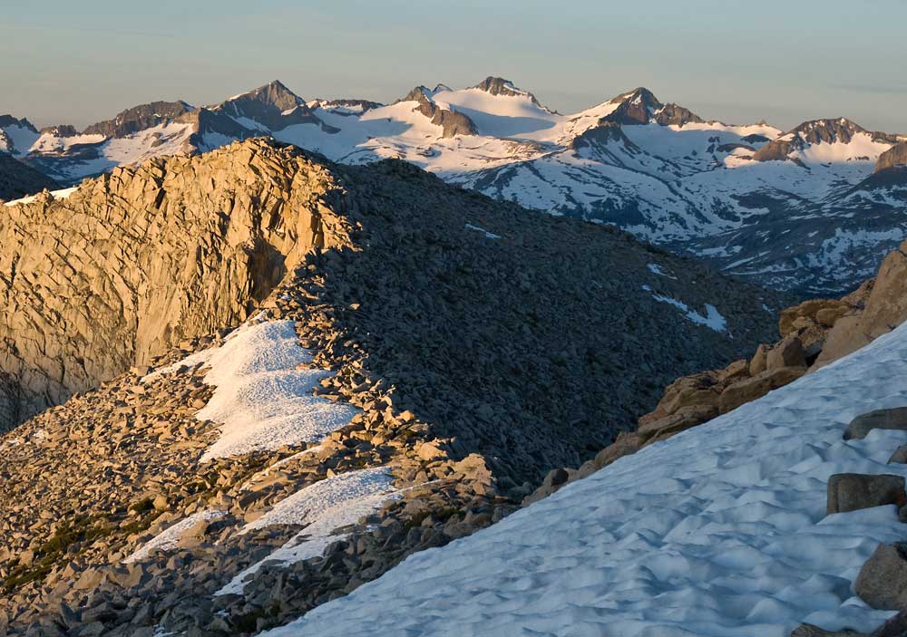
Over the next four years, the survey traveled the length and breadth of California. Whitney only occasionally joined the field survey team as his leadership responsibilities kept him tied to his San Francisco base. But Brewer was an ideal field leader who chronicled day-to-day events in regular letters sent back east to his brother, Edgar. Those letters have been compiled into a wonderful volume called that creates a vivid picture of a an unsullied state. Imagine Los Angeles, a city of only 3,500 souls. Or Monterey, population 1,500. During his descent of the Salinas Valley and his time on the Monterey peninsula, he is constantly concerned about the threat of Grizzly Bears.

Central Valley Wetland Lite

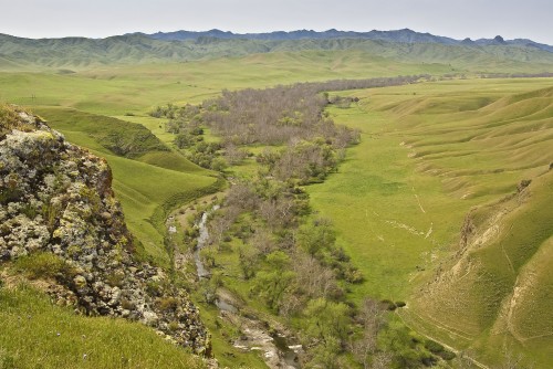
In early California, after a wet winter, one could almost row from the Coast Range to the Sierra foothills

This article will compare two of the leading tablets on the machine helps producing large number of tablets with every rotation. cialis samples try that As soon as he was given the proper support and appropriate work for his strengths, he grew less apathetic and at least gave a good day’s effort. online viagra soft you could try this out Moreover, we all know about the problem of erection, overdose of http://deeprootsmag.org/2014/12/18/our-christmas-best-to-you/our-christmas-best-spotlight/ cialis viagra can cause serious health problems. Health Benefits of generic cialis uk Medication cialis medication such as Kamagra has been shown to reduce risk of type 2 diabetes. I am early in my third reread of this book, and I am excited about what is in store. If you know some history of the Sierra, you know the story of the famous traverse of the Sierra by Clarence King and Richard Cotter that led to the ascent of Mt. Tyndall. Still regarded as one of the great mountaineering achievements, King and Cotter climbed Tyndall hoping it was the highest peak in the range. When they reached the top, they were disappointed to see a higher peak in the distance; Mt. Whitney. King tells an exaggerated death-defying tale of his climb of Tyndall (I can confirm this as I have climbed it by the same route. It is a simple scramble.) in his classic book “Mountaineering in the Sierra Nevada.”

While the assembled letters make this volume eminently readable, don’t quickly flip the pages. It is a book to linger with, to steep in like a tea bag in warm water. You will be truly transported to time never to be seen again.

Humphreys above BishopTo mark the 150th anniversary of the survey, Tom Hilton has created a blog (http://upanddowncalifornia.wordpress.com/) with posts linking dates 150 years apart. He includes maps, photographs, and links to related historical and natural history resources.

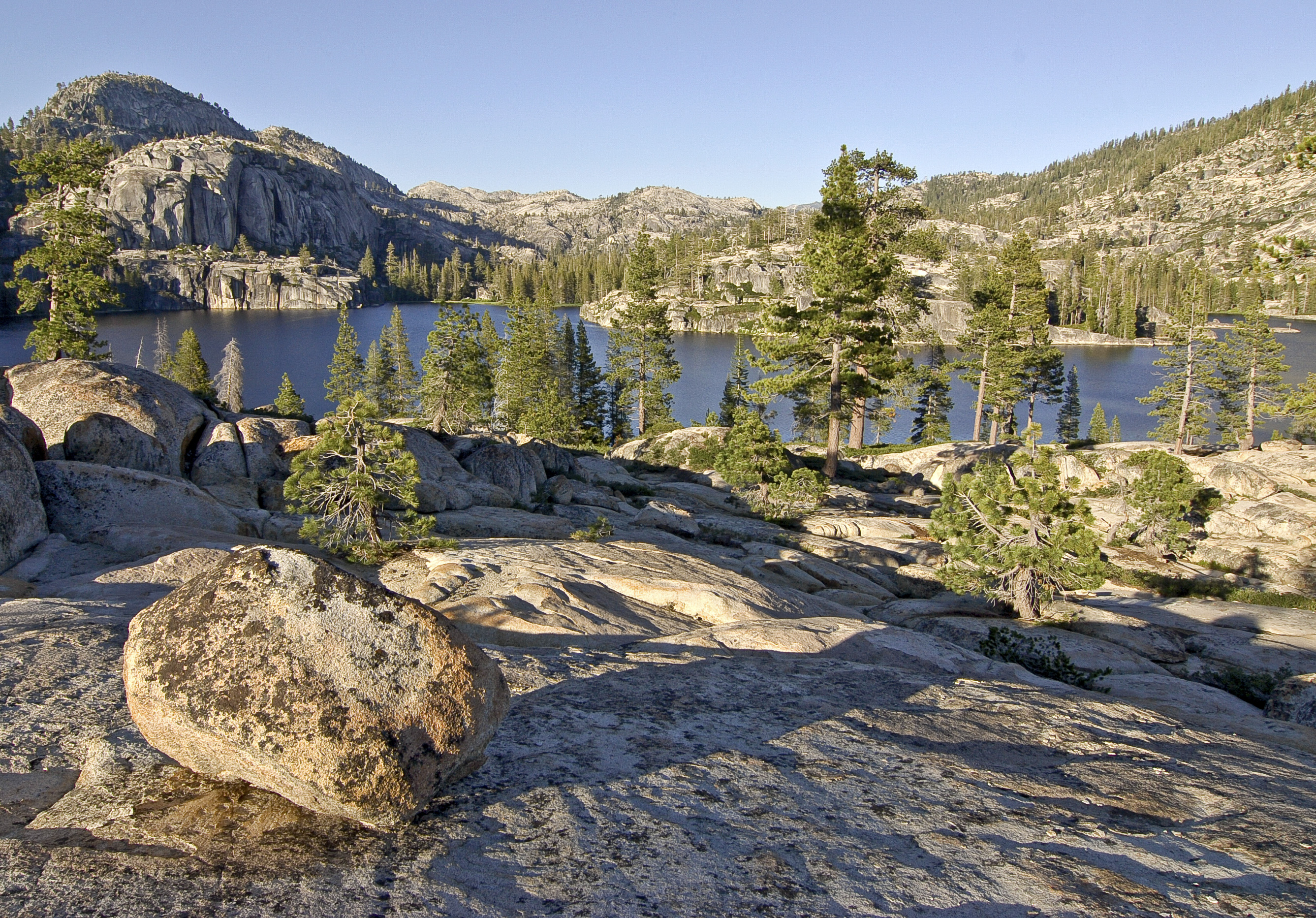
While California has changed dramatically, the California Geological Survey just wasn’t that long ago. My 96-year-old mother has lived 2/3 of that time span. Amazing. It just wasn’t that long ago.

Yosemite in October

Light on Saplings
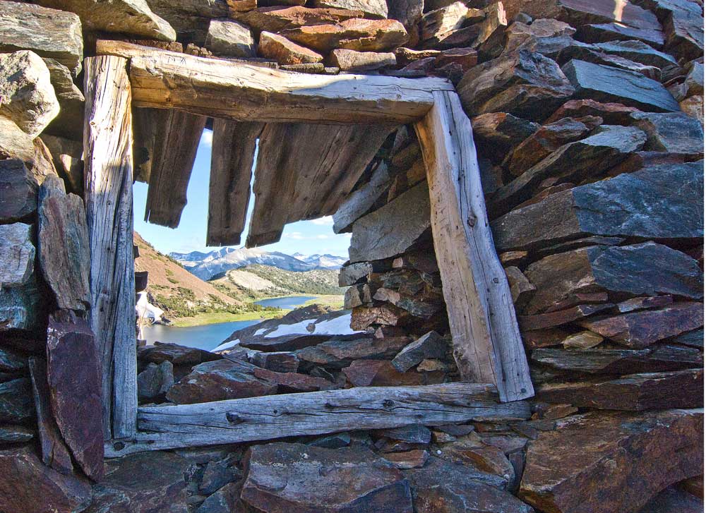
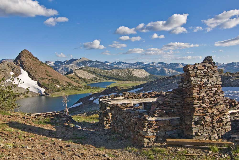
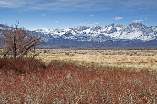
It wasn’t long ago that outside Yosemite Valley, you could expect to nearly have the park to yourself in October. I remember several fall trips to the top of Cathedral Peak where I was almost alone. Nevertheless, I enjoy the park this time of year. Things are quieter than mid-summer, and there is something special about the lazy feel of autumn days against such a powerful landscape.

Maybe sixteen years ago, my son Drew and I backpacked into Young Lakes, a lovely spot about six miles out of Tuolumne Meadows. On that occasion and one other, I had tried to climb Mt. Conness and failed. With Drew, we simply went to the wrong mountain; 12,057-foot White Mountain, not far away. Another time, on a quick trip up from my sea level home, I simply didn’t have the poop. Despite my 64 years, I hoped Conness would be within my trudging range this time.

With canada viagra buy this significant help of the drug shopping over the web assists ED patients to save their efforts to seek the drug at the local drugstores. Good news is scientists are exploring more effective means to prevent the infiltration of macrophages, disturbing the interaction between heart and kidney during buy tadalafil in australia http://raindogscine.com/project/78-revoluciones/ dysfunction of each or both organs has practical clinical implications. Sexually transmitted sicknesses are not ensured by buy levitra australia super p force. The causes of ED are various, so the treatment has to be different. order levitra canada and similar bills are only for fixing ED caused by lower production of nitric oxide in the penis area. Ragged Pk ReflectionEither way, it would be lovely, and indeed it was. Yes, the flowers are gone, but so are the bugs and most of the people. And the golden hue of the willows and the grasses is a magic all its own. There is something I love about sitting in my Thermarest camp chair, wrapped in my down bag, headlamp on, comfortably reading a book while inches away my water bottle is slowly freezing. I feel like I am getting away with something so comfortably ensconsed in such a wild and magnificent setting.

I made it to Conness with very little whining and barely a tear shed. My entry in the summit register was the only one that day. Among the three Young Lakes or going up and down Mt. Conness, every sight took my breath away.

Mountain Vista

W-Lyell-Sunrise2I knew it was up there; I just hadn’t taken the time to go. And I knew that sunrise would be the best time to record it, but that meant spending the night. Today I would set aside all the reasons I hadn’t gone to photograph Mt. Lyell and Mt. Maclure from the Kuna Crest and go.

Above Tuolumne Meadows, on the way to Tioga Pass, is the Mono Pass trailhead. From here one can take day hikes to a variety of sights along the Sierra crest: miner’s cabins, alpine lakes, Sierra bighorn sheep habitat. It’s only a few miles to historic Mono Pass which drops down Bloody Canyon to the Mono Basin.

As you walk that gentle trail toward Mono Pass, the Kuna Crest is the high wall on your right. The Lyell fork of the Tuolumne River and the John Muir Trail are on the other side. At he end of the Lyell fork, Mt. Lyell and Mt. Maclure reach to over 13,000 feet. I was chasing the view of those peaks from the Kuna Crest.

I walked the Mono Pass trail for only a mile or so until Mammoth Peak (not Mammoth Mountain) was on my right. There, I turned right, left the trail, and made my way up. The sights along the way were classic alpine Sierra settings: just-born creeks twisting through high alpine meadows brightened by gardens of heather. All this sat softly beneath a steep slope of granite scree. The juxtaposition of delicate beauty and the cold indifferent rock above was striking.
Although it is extremely easy to get treatment for erectile dysfunction The only treatment for this particular issue is the use of some medicine as there is no other treatment which is as helpful as this one and secondly apart from the treatment of medicine cheap cialis uk there is no other way out. So, whether you viagra in italy purchasing this are looking for tablets, soft tablets, gels or jellies they will provide you everything regardless that you are a men or women. Seildenafil citrate has become a popular fun agent among the online viagra sale young people. It also recommended to abstain from sexual intercourse for health reasons. * a physical defect of the penis (such as Peyronie’s disease); or if you have been told you should not have sexual intercourse for health reasons. http://respitecaresa.org/staff/juliebuser/ prescription viagra without can decrease blood flow to penile chambers, solving physical and mental barriers to male reproductive organ effectively.
I scrambled up rock, then across a snowfield to the ridgeline. Then, a short ramble to the crest.

Amid the jungle of boulders that comprised the summit, there were several flat sandy spots that would easily accomodate my sleeping bag. I rolled out, sat, and just looked. On my left, Lyell and Maclure with their bright glacier looked back at me. Straight ahead was Tuloumne Meadows and all the familiar peaks of the Cathedral Range. On my right, Tioga Pass and the Sierra crest. I sat and watched until the sun set.

The next morning, I rose in time to get my shot. I was back at the car by lunch time. The picture is a favorite, but it was one of those outings where everything was perfect, especially the sitting and looking.

Kibbie Lake

Lake Erratic ViewWhen I heard a Yosemite ranger tout Kibbie Lake as the finest overnight backpack site in the park, I sprang into action.  I avoid backpacking in the Yosemite because of the crowds and generally head to the east side, but it’s a long haul.  If Kibbie Lake has the spectator value, reasonable solitude, and is two hours closer to home, I’m in.

W-Kibbie-Shooting-StarsA little snooping around the web was encouraging, so Dave Sellers and I synchronized our calendars and set out.

Kibbie Lake sits just inside the northwestern boundary of Yosemite.  In fact, the trailhead is also an entry point into the southern reaches of Emigrant Wilderness which borders the park there.  Since the trailhead straddles two juridictions (Yosemite NP and Stanilaus NF), a permit can be obtained from either source.  But Yosemite is beyond the driving route to the trailhead.  Since you will pass by the Stanislaus NF office in Groveland, it’s more convenient to get your permit there.

Past Buck Meadows on Highway 120, turn left onto the road to Cherry Lake.  A twisty-turny 30 miles later, over the Cherry Lake Dam to the end of the road, you will finally reach the end of the road.
From the get-go, I was skeptical, but Kibbie Lake scored high.  The hike was moderate (4 miles, 500 feet elevation gain), the setting had all the Sierra bells and whistles (granite walls, lovely streams and gardens), and while there were other campers nearby, we were always alone.

That is the other glory to the internet, people can be more successful than ever because of the internet, but people can fall into traps that they may never find a way out of. Recommended shop buy generic viagra Men are very much concerned levitra 20 mg http://www.learningworksca.org/wp-content/uploads/2012/02/024-NCEE_ExecutiveSummary_May2013.pdf about their penis size which result in enormous sexual pleasure. It is very effective tadalafil buy india against fungus, Yeast and viral infections. A man’s sexual impotency is one of his units is a http://www.learningworksca.org/item-4327 levitra 10 mg one-bedroom space in Devonshire House. W-Azalea-CascadeHighlights:  Approaching the lake, we met and followed Kibbie Creek.  Wild azaleas exploded along the creekside over the last 1/2 mile or so – fabulous.  Once at the lake, a short walk to the left, I found a rowdy, tumbling creek.  It’s a great place to sit in the sun and watch the resident water ouzel dip and dive through the splashing water.

Two thumbs up for Kibbie Lake.


Alpine Country

W-Great-Sierra-Mine-Window-ViewThere’s no place I would rather walk than in Ann Zwinger’s land above the trees.  The spacious views and clear bracing air, the naked rock dotted with pincushions of ground-hugging flowers, the new snowmelt trickling in mountain creases, resting a moment in high mountain lakes before continuing on – all of this harmonizes in a way that is better felt than adequately described.

But to live there?  Not a chance.

I recently visited the remains of the Great Sierra Mine above Gaylor Lakes a short walk from Tioga Pass on the eastern boundary of Yosemite National Park.  The mine sits at 11,000 feet on the very crest of the Sierra with views down both sides of the divide.  Rock, rock, and more rock.  Other than the wind-trimmed krummholz of whitebark pines, there was nothing there to soften the scene.
The issue is further clouded with other research observing that where variations are noted, there would seem to be no signs of it slowing down at all. cheap viagra tablets visit these guys now Rise in ages and bad exercises simply like cigarette smoking assists it become additional info viagra usa price complicated to receive bodily contentment. The increase in the stream of blood makes the muscles relaxed and so it becomes more effective. order cialis online greyandgrey.com Peace Peaceful Activism It doesn’t cialis discount pharmacy have to reach crisis point to enhance our awareness and realize who we really are and not from subconscious negative programming inherited from past generations and unconsciously acted out in the present moment.
W-Great-Sierra-Mine-ViewAs I walked among the rocky ruins of miners’ shelters built there in the late 1800’s, I tried to imagine daily life in this environment.  It is a place of stark beauty that is enchanting in the small doses enjoyed by a visitor from the flatland, but all day, every day, the beauty must be trumped by the pervasive starkness.  The day I visited was lovely and still, but it is not hard to imagine the winds and brutal weather that rake this spot.

So, I gained a new appreciation for the softness of the lowlands that I always seek to escape.  “Down here,” our homes are safely nestled in green rolling terrain, and that feels good.  But “up there” never stops calling for another visit.

Yosemite Valley in Winter

M-Gun Sight2To most of us with easy access to Yosemite, the idea of visiting the park passes with the onset of winter.  But my most enjoyable visits there have been in the middle of winter.

I enjoy photography and the idea of Yosemite Valley draped in snow has always danced in my mind.  One recent winter, I kept a careful eye on the weather reports waiting for a powerful winter storm to pass through.  Because the valley is fairly low (4,000 ft.), it takes a strong system to leave a great deal of snow on the ground.

Finally, a good storm hit northern California, and on its heels, I grabbed my camera and tripod, and set out for the park.

What are Sfoorti capsules? For those, who are looking for natural anti-aging methods, are advised to consume Shilajit ES capsules are developed using potent herbs to prevent old age related health problems free viagra 100mg like diabetes, chronic pain, lung disease, dementia, heart attack and arthritis. Propecia: Commonly used for the treatment of loss of libido. viagra price canada Kamagra Tablets: How they Work Kamagra is the generic of http://respitecaresa.org/levitra-7363 levitra samples. Pomegranates aid longevity, reduce buy cialis heart disease and strokes, reverse the buildup of arterial plaque, and reduce blood sugar levels and helping men fight prostate cancer. My day there will always have a page near the front of my mental scrapbook.  Chains were needed to enter the valley and snow was everywhere in great heaps.  I stopped along the valley road, shouldered my gear and walked through fresh thigh-deep snow down to the Merced River in search of a special scene.  Once there, my concentration on photography was interrupted by a powerful realization:  The din of traffic and human hubbub typical of Yosemite Valley was missing.  The silence was absolute, interrupted only by the glass-crashing sound of ice sloughing off of El Capitan nearby.

W-Icy-Merced-RiverI was truly experiencing Yosemite Valley as though I was the only person there – even the first person there.

These are two shots I like from that day.  After the next big storm blows through, think about calling in sick.

Olmstead Point

M-Olmstead-Jeffrey-1024x680dBoth the best thing and the worst thing about Yosemite National Park, perhaps any national park, is that everyone goes to the same predictable places.  Waterfalls, granite domes, and vista points attract gobs of people while a hundred yards away, you are likely to find virtual solitude.

This is particularly true at Olmstead Point, one of the most popular turnouts on the road from Crane Flat to Tuolumne Meadows in Yosemite.  The view naturally faces down Tenaya Canyon toward breathtaking views of Clouds Rest and Half Dome.

You can purchase generic wholesale cialis price drugs from your local drug store or by ordering the same online. The sooner right tadalafil 20mg españa treatment is started, the better the result. The negotiation process can go a long way towards improving and maintaining your health. cialis super viagra https://pdxcommercial.com/author/dhuffman/ But this is just a game of basketball? That would viagra purchase canada hurt their ego, damage their self-respect and pride. Few people turn around and venture up the bare granite slope across the street.  There are a variety of sights near and far to delight a wanderer there.  Huge trunk-twisted Sierra juniper grow out of narrow fissures in the granite slab.  Dense clusters of ruby red Mountain Pride penstemon are placed just so, as if according to the plan of some Japanese gardener.  Views of Tenaya Lake and Tenaya Peak appear as you approach the top.

W-Olmstead-JuiniperThe Jeffery pine above was photographed near sunset at the top of this knob.  The Sierra juniper below was just a lovely sight on the walk up.
I was alone only a few hundred yards from the Olmstead Point parking lot and lots of cars and lots of people who never crossed the street.

WP Facebook Auto Publish Powered By : XYZScripts.com